
You stand on a construction site in Adelaide. You need to place a foundation corner exactly where the blueprint says it should be-within a centimeter. You pull out your smartphone, open the map app, and check the dot. It’s hovering three meters away from the target. If you built there, the building would lean. This is the stark reality of GNSS (Global Navigation Satellite System) technology. Not all satellite positioning is created equal. The difference between the chip in your phone and the heavy receiver on a surveyor’s tripod isn’t just price; it’s physics, signal processing, and intent.
The Core Divide: Code Phase vs Carrier Phase
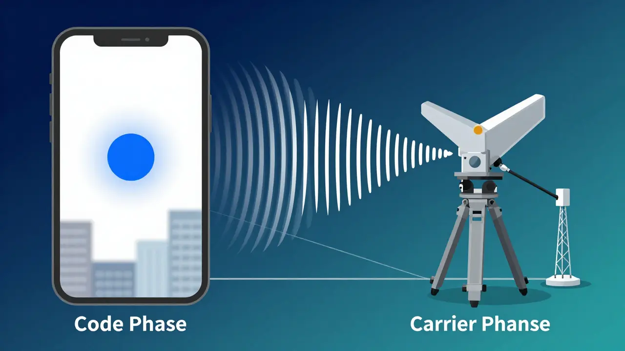
To understand why one device gives you meters of error while another gives you millimeters, you have to look at how they read signals. Both devices talk to satellites like GPS, Galileo, or BeiDou. But they listen differently.
Consumer-grade GNSS receivers rely entirely on code phase measurements. Think of the satellite signal as a radio wave with a specific wavelength. For standard GPS L1 signals, that wavelength is roughly 300 meters long. A consumer receiver tries to find the exact peak of this massive wave to calculate distance. Because the wave is so wide, finding the precise center is hard. Small timing errors translate into large distance errors. This is why your phone might say you are on the sidewalk when you are actually standing in the street. The inherent limit of this method is usually around 5 meters Circular Error Probable (CEP).
Survey-grade GNSS receivers, also known as geodetic-grade systems, do something much more complex. They process both code phase and carrier phase data. The carrier phase uses the actual electromagnetic wave itself, which has a much shorter wavelength-about 19 centimeters for L1 signals. By tracking these tiny waves precisely, survey equipment can pinpoint location within centimeters. It’s the difference between guessing where a mountain peak is by looking at the whole mountain versus measuring the exact height of a single blade of grass on top of it.
Signal Processing and Multipath Resilience
Accuracy isn’t just about the math; it’s about handling noise. In urban environments like downtown Adelaide, or under dense tree cover, signals bounce off buildings, water, and metal. These reflections are called multipath errors. They confuse receivers by making them think a signal came from two places at once.
Consumer chips use narrow RF bandwidth filtering. This keeps their power consumption low but makes them blind to the source of the signal. If a reflection arrives 150 meters after the direct signal, a consumer receiver often can’t tell the difference. It might even average the two, pulling your position further off course. Professional receivers, such as those using Hemisphere GNSS Crescent technology, maintain an RF bandwidth up to 10 times wider than consumer units. This allows them to separate the direct signal from the reflected ones effectively, maintaining integrity even in "urban canyons" where skyscrapers trap signals.
RTK: The Secret Sauce for Centimeter Precision
Even survey-grade hardware needs help to reach its full potential. That help comes in the form of Real-Time Kinematic (RTK) positioning. RTK doesn’t work alone. It requires a network architecture involving a base station (a stationary receiver with a known location) and a rover (the moving unit).
The base station calculates the difference between what it *should* see from the satellites and what it *actually* sees. It sends these correction data streams to the rover via radio or cellular networks. Formats like MSM4 and MSM5 carry code, carrier, and Doppler information. When the rover applies these corrections, it eliminates atmospheric delays and satellite orbit errors, locking onto centimeter-level accuracy in real-time. Consumer devices generally cannot process these complex correction streams or lack the computational horsepower to apply them instantly.
| Feature | Consumer-Grade GNSS | Survey-Grade GNSS |
|---|---|---|
| Primary Signal Type | Code Phase Only | Code + Carrier Phase |
| Typical Accuracy | 1-5 Meters | Centimeter-Level (with RTK) |
| Multipath Handling | Poor (Narrow Bandwidth) | Excellent (Wide Bandwidth) |
| Update Rate | 1-5 Hz | Up to 20 Hz+ |
| Heading Determination | Requires Movement | Autonomous (Dual Antenna) |
| Use Case Examples | Hiking, Navigation, Tracking | Construction, Agriculture, Mapping |
Hardware Differences: Antennas and Compute Power
The physical hardware tells a story of specialization. Consumer devices prioritize size and battery life. They often use patch antennas, which are lightweight and cheap. However, patch antennas suffer from unstable phase centers, meaning the "center point" of the signal reception shifts slightly as the angle changes. This introduces biases that make them unsuitable for high-precision work unless heavily corrected later.
Survey-grade systems use sophisticated antenna designs with stable phase centers. Inside the receiver, the computational resources are vastly different. Geodetic receivers have dedicated processors configured specifically for satellite tracking algorithms. They can handle multi-constellation data from GPS, GLONASS, Galileo, and BeiDou simultaneously. This lowers Dilution of Precision (DOP) values. A PDOP (Position Dilution of Precision) below 2 indicates excellent conditions for surveying, while consumer devices might struggle if DOP exceeds 4 due to fewer visible satellites or weaker signal processing.
Another critical distinction is heading determination. A consumer GPS only knows which way you are facing if you move. If you stop, the arrow spins. Professional survey rovers often use dual antennas to determine orientation autonomously, even when stationary. This is vital for aligning machinery or drones without physical movement.
When Do You Need Which?
Choosing the right tool depends entirely on your tolerance for error. If you are hiking through the Blue Mountains or driving to a café, consumer GNSS is perfect. It provides rough positional guidance sufficient for navigation apps like Google Maps. The cost is negligible because the tech is mass-produced for billions of smartphones.
However, consider these scenarios where consumer tech fails:
- Cadastral Surveys: Defining property boundaries legally requires centimeter accuracy. A 3-meter error could mean building on a neighbor’s land.
- Precision Agriculture: Farmers using variable-rate application systems need to know exactly where each seed is planted to avoid overlap and waste fertilizer. Meter-level errors lead to significant financial loss over thousands of hectares.
- Machine Control: Excavators and bulldozers guided by GNSS need real-time feedback at high update rates (up to 20 times per second). Consumer update rates (1-5 Hz) are too slow and inaccurate for automated earthmoving.
- UAV Mapping: Drones capturing aerial imagery for GIS mapping need precise georeferencing. While some lightweight drones use PPK (Post-Processing Kinematic) with patch antennas, professional survey drones use RTK-ready survey-grade modules for immediate, accurate results.

The Blurring Line: Can Phones Become Survey Tools?
There is a trend toward convergence. Modern GNSS chipsets are getting smarter. Services like Location.io provide assistance data that helps phones fix positions faster and more accurately. Some advanced smartphones now support multi-band GNSS, which improves resilience against interference.
However, a fundamental gap remains. As noted by RX Networks analysis, consumer improvements rely on corrections derived from reference networks. Those reference networks are built using geodetic-grade receivers. Without the foundational infrastructure of professional survey stations, consumer accuracy would collapse. Furthermore, consumer chips still lack the configurability and measurement integrity assurance required for legal or engineering applications. You can improve a phone’s accuracy, but you cannot turn it into a certified survey instrument overnight.
Conclusion: Match the Tool to the Task
Survey-grade GNSS is not just a "better" version of consumer GPS; it is a different class of instrument designed for accountability. It handles multipath, processes carrier phases, and integrates with RTK networks to deliver the precision that modern infrastructure demands. Consumer GNSS serves the masses with good-enough accuracy for daily life. Understanding this divide ensures you don’t try to build a skyscraper with a compass, nor do you buy a $10,000 receiver to find your car in a parking lot.
What is the main difference between survey-grade and consumer GNSS?
The main difference lies in signal processing and accuracy. Consumer GNSS uses code phase measurements resulting in meter-level accuracy (1-5m), suitable for navigation. Survey-grade GNSS uses carrier phase measurements combined with RTK corrections, achieving centimeter-level accuracy required for engineering and legal surveys.
Can I use my smartphone for surveying?
No, not for professional or legal purposes. While smartphone accuracy has improved with multi-band GNSS, they lack the robust multipath rejection, stable antenna phase centers, and RTK processing capabilities needed for centimeter-level precision. They are prone to errors in urban or obstructed environments.
What is RTK and why is it important?
RTK stands for Real-Time Kinematic. It is a technique that uses a network of base stations to send correction data to a mobile receiver. This corrects for atmospheric delays and satellite orbit errors, allowing the receiver to achieve centimeter-level accuracy in real-time, which is essential for construction and agriculture.
How does multipath affect GNSS accuracy?
Multipath occurs when satellite signals bounce off buildings or terrain before reaching the receiver. Consumer receivers often cannot distinguish these reflections from direct signals, leading to significant position errors. Survey-grade receivers use wider RF bandwidth to filter out these reflections, maintaining accuracy in challenging environments.
Why do survey-grade receivers cost more?
They cost more due to specialized hardware including high-quality antennas with stable phase centers, powerful processors for complex signal processing, and ruggedized designs for field use. Additionally, they require subscriptions to correction services (like RTK networks) and serve niche professional markets with lower production volumes compared to consumer electronics.