

You are driving through a city center, watching your phone's blue dot jump from one lane to another, then suddenly teleporting across the street. It’s frustrating, right? You aren't losing signal; you're being tricked by physics. This phenomenon is known as GPS multipath, where radio signals bounce off buildings and surfaces before reaching your receiver, creating ghost images of the satellite. While it sounds like a minor glitch, for surveyors, pilots, and autonomous vehicles, these errors can mean the difference between hitting a target or missing it by meters. Understanding why this happens and how to stop it is essential for anyone relying on precise location data.
The Physics of Bounced Signals
At its core, multipath error occurs when a satellite signal reaches an antenna via two or more paths: the direct line-of-sight path and one or more reflected paths. Your GPS receiver is designed to assume that the first signal it detects traveled directly from the satellite. But if a signal bounces off a skyscraper, a wet road, or even a nearby car, it travels a longer distance. The receiver interprets this extra travel time as a greater distance to the satellite, skewing the position calculation.
Think of it like hearing an echo in a canyon. If you shout and hear your voice return twice-once directly and once after bouncing off a wall-you might get confused about which direction the sound came from. In GPS terms, the "echo" is a delayed signal. When the delay is short (less than 30 meters), the receiver often cannot distinguish the direct signal from the reflected one. Instead, it sees a distorted composite signal. This distortion shifts the estimated timing, leading to position errors that can range from centimeters in high-end systems to several meters in consumer devices.
The severity of the error depends heavily on the environment. Urban canyons, with their tall glass and steel facades, are notorious for creating strong, coherent reflections. A study in 2026 highlighted that building-obstructed environments produce more irregular and stronger multipath effects compared to tree-obstructed areas, where vegetation tends to scatter signals diffusely rather than reflecting them cleanly. Water bodies and wet asphalt are also significant reflectors, particularly at low satellite elevation angles, because the ground occupies a large portion of the antenna's lower view.
Why Code and Carrier Phase React Differently
Not all GPS measurements suffer equally from multipath. There are two main types of observables used in positioning: pseudorange (code) and carrier phase. They react differently to bounced signals, which dictates how we mitigate them.
Pseudorange measurements are based on the code sequence transmitted by the satellite. They are robust but noisy. The theoretical limit for code multipath error is roughly 1.5 chips of the code length. For the standard GPS C/A code, this could theoretically reach 450 meters, though typical values are much lower, usually under 2-3 meters. However, in severe urban environments, these errors can spike significantly.
In contrast, carrier-phase measurements track the phase of the radio wave itself. They are incredibly precise, capable of millimeter-level accuracy, but they are ambiguous without additional processing. Multipath affects carrier phase differently: the maximum error is limited to one-quarter of the wavelength. For GPS L1 frequency, this means a hard cap of about 5 centimeters. Typical carrier-phase multipath is often below 1 centimeter. This is why high-precision surveying relies heavily on carrier phase-it naturally suppresses large multipath errors that plague code-based navigation.
| Observable Type | Theoretical Error Limit | Typical Error Range | Sensitivity to Environment |
|---|---|---|---|
| Pseudorange (Code) | ~1.5 chips (~450m max) | 1-3 meters (up to 15m+ in severe cases) | Highly sensitive to short-delay reflections |
| Carrier Phase | ~1/4 wavelength (~5cm) | < 1 cm | Less sensitive, but prone to cycle slips |
The First Line of Defense: Site Selection and Antennas
You can’t fix bad physics with software alone. The most effective way to combat multipath is to prevent it from happening in the first place. This starts with where you put the antenna and what kind of antenna you use.
If you are installing a permanent station, such as for a weather network or a base station for RTK corrections, location is everything. The U.S. National Geodetic Survey recommends placing antennas as high as practical, away from reflective surfaces like walls, roofs, fences, and metallic structures. A clear horizon is critical. If your antenna is surrounded by glass buildings, you’re inviting multipath. Even something as simple as a nearby chain-link fence or a parked truck can introduce significant errors if it reflects a strong signal.
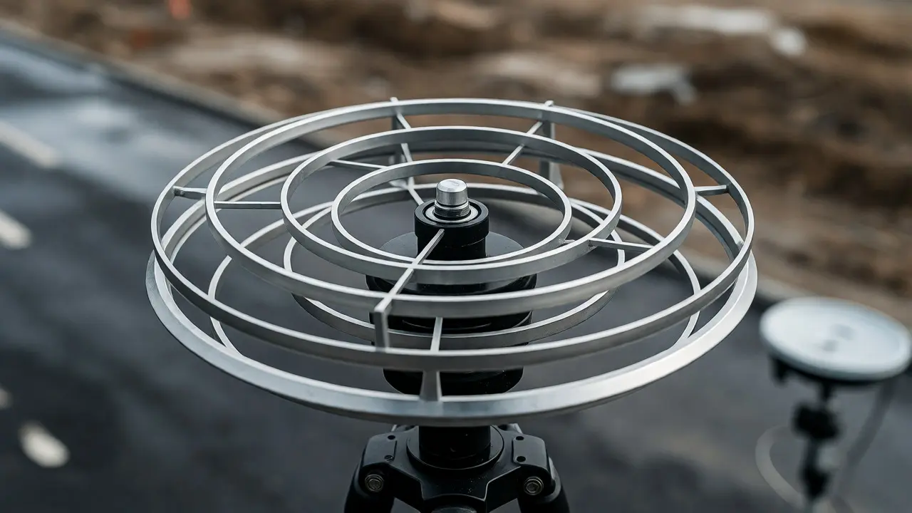
Antenna design plays a pivotal role. Standard patch antennas found in phones accept signals from almost any angle above the horizon. Geodetic-grade antennas, however, are engineered to reject low-elevation signals, where multipath is most prevalent. Choke-ring antennas use concentric rings around the radiating element to create a deep null in the gain pattern near the horizon. This effectively blocks signals arriving at shallow angles, which are likely to be reflected from the ground or nearby structures. While expensive and bulky, choke-ring antennas remain the gold standard for static surveying installations.
For mobile applications, where you can’t carry a meter-wide choke ring, smaller solutions exist. Multi-beam antennas and controlled-pattern arrays can steer sensitivity away from known reflectors. Some advanced designs incorporate absorbing materials, such as Eccosorb AN-W-79, which reduce reflected energy by more than 17 dB above 600 MHz. These materials absorb stray signals before they interfere with the direct path, acting like acoustic foam for radio waves.
Receiver Intelligence: Correlators and Algorithms
Once the signal hits the antenna, the receiver’s internal electronics take over. Modern receivers don’t just passively listen; they actively analyze the shape of the incoming signal to detect distortions caused by multipath.
One common technique involves manipulating the correlator spacing. Traditional receivers use wide early-late correlators, which average out noise but are susceptible to multipath-induced slope changes in the correlation peak. By narrowing the correlator spacing-for example, to 0.1 chips-a receiver becomes more sensitive to sharp delays. NovAtel, a leading GNSS hardware provider, reports that narrowing spacing can improve pseudorange accuracy by a factor of two compared to standard settings. Their Pulse Aperture Correlator goes further, claiming a fourfold reduction in multipath effects by specifically targeting short-delay distortions.
Beyond hardware tweaks, algorithms play a crucial role. Receivers monitor metrics like Signal-to-Noise Ratio (SNR) and Carrier-to-Noise density (C/N0). A sudden drop in SNR for a specific satellite, especially when combined with inconsistent residuals in the position solution, flags a potential multipath issue. Advanced receivers use stochastic weighting models, assigning lower confidence to observations from satellites at low elevation angles or those showing signs of signal distortion. This doesn’t eliminate the error, but it reduces its impact on the final position estimate.
Another powerful tool is multi-frequency processing. Modern satellites transmit on multiple frequencies (L1, L2, L5, etc.). Because multipath effects vary slightly with frequency, comparing measurements across bands helps identify anomalies. While dual-frequency combinations primarily correct ionospheric delays, they also provide redundancy that aids in detecting non-line-of-sight conditions. If a satellite’s signal quality degrades disproportionately on one frequency, the receiver can choose to exclude that measurement entirely.
Post-Processing and Modeling Techniques
For real-time applications, you have to work with what you have. But for post-processing, such as analyzing survey data or scientific research, you have the luxury of time and historical context. Here, modeling becomes a potent weapon against multipath.
Sidereal filtering exploits the fact that satellite geometry repeats approximately every sidereal day (23 hours, 56 minutes, and 4 seconds). If a multipath error is caused by a static reflector (like a building), it will likely recur at the same time each day. By recording the residuals (errors) from previous days, analysts can predict and subtract these systematic biases from current data. This method is highly effective for static stations but less so for moving platforms where the reflector geometry changes constantly.
A more sophisticated approach is the Multipath Hemispherical Map (MHM). Instead of treating time as the primary variable, MHM maps multipath corrections based on the azimuth and elevation of the satellite. It builds a 3D model of the local environment’s reflective properties. A 2024 study demonstrated that using multi-GNSS MHM reduced the convergence time for Precise Point Positioning (PPP) by 24.1% and improved overall accuracy by nearly 14%. Recent advancements include trend-surface modeling, which smooths the map to handle sparse data better, yielding RMS error reductions of up to 39% in vertical components.
Digital filters offer another avenue. Since multipath often manifests as low-frequency oscillations in the residuals, band-stop or low-pass filters can attenuate these components. Studies comparing Butterworth, Chebyshev, and elliptic filters have shown that while no single filter is perfect, adaptive filtering techniques can separate line-of-sight signals from reflected ones in software-defined radios. However, caution is needed: aggressive filtering can remove genuine dynamic movement, making it unsuitable for fast-moving vehicles.
The Role of Machine Learning
As with many fields, artificial intelligence is entering the arena. Researchers are training Convolutional Neural Networks (CNNs) to recognize the unique signatures of multipath-distorted correlation functions. Unlike traditional threshold-based methods, a neural network can learn complex patterns in the raw signal data that human engineers might miss.
A 2024 paper described a CNN trained on synthetic noisy correlator outputs, capable of distinguishing clean signals from those corrupted by multipath. The system can either hard-remove contaminated observations or apply soft weighting in the least-squares estimation. More recent hybrid architectures, combining attention mechanisms with random forests, show promise in urban detection tasks. However, machine learning isn’t a magic bullet. These models require vast amounts of representative training data. If deployed in an environment unlike the training set (distribution shift), they may fail catastrophically. Therefore, AI currently complements, rather than replaces, physical mitigation strategies.
Practical Takeaways for Different Users
So, what should you actually do? The strategy depends on your precision needs and budget.
- For Consumer Navigation: Keep your phone or dash cam mounted high and away from metal accessories. Avoid parking under dense bridges or inside tight garages if possible. Trust the map less when navigating narrow streets with tall buildings.
- For Hobbyist Drone Pilots: Use a GPS module with a good ceramic patch antenna. Enable SBAS (Satellite-Based Augmentation System) if available, as it provides integrity checks that can flag unreliable fixes. Be wary of flying near large metal structures or water bodies.
- For Professional Surveyors: Invest in a geodetic-grade antenna with a ground plane or choke ring. Choose sites carefully, avoiding obvious reflectors. Use dual-frequency receivers and enable multipath-resistant tracking modes. For highest accuracy, perform redundant observations at different times of day to average out geometric dependencies.
- For Autonomous Vehicles: Rely on sensor fusion. GPS alone is insufficient in urban canyons. Combine GNSS data with LiDAR, cameras, and inertial measurement units (IMUs). Use HD maps to constrain the vehicle within known road boundaries, effectively overriding erratic GPS jumps.
No single technology eliminates multipath. It is a fundamental property of electromagnetic propagation. The best results come from a layered defense: smart siting, appropriate antenna hardware, intelligent receiver processing, and, where applicable, environmental modeling. As satellite constellations grow and signal processing advances, our ability to see through the noise improves, but the shadow of the building remains a constant challenge in the world of satellite navigation.
Can differential GPS correct multipath errors?
Generally, no. Differential GNSS (DGNSS) works by canceling out errors that are common to both the reference station and the rover, such as atmospheric delays and satellite clock errors. Multipath is local to the specific receiver environment. A reflection off a building near the rover is unlikely to occur identically at the reference station kilometers away. Therefore, DGNSS does not effectively remove multipath, requiring dedicated mitigation techniques instead.
How big is a typical GPS multipath error?
For standard consumer GPS using code measurements, typical multipath errors range from 1 to 3 meters, though they can exceed 15 meters in severe urban environments. For high-precision carrier-phase measurements used in surveying, the error is much smaller, typically less than 1 centimeter, with a theoretical maximum bound of about 5 centimeters for GPS L1 signals.
Do trees cause multipath errors?
Yes, but differently than buildings. Trees tend to attenuate and scatter signals diffusely rather than creating strong, coherent reflections. This results in signal loss and increased noise rather than the distinct positional jumps seen with flat, reflective surfaces like glass or water. However, dense foliage can still degrade signal quality and contribute to positioning uncertainty.
What is a choke-ring antenna?
A choke-ring antenna is a specialized GNSS antenna designed to suppress multipath errors. It features concentric rings around the central radiating element that create a deep null in the antenna's gain pattern near the horizon. This design blocks signals arriving at low elevation angles, which are most likely to be reflected from the ground or nearby structures, thereby improving accuracy for static surveying installations.
Can software alone fix multipath?
Software can mitigate, but not completely fix, severe multipath. Receiver algorithms like narrow correlators and stochastic weighting help reduce the impact, and post-processing models like sidereal filtering can correct systematic biases. However, if the physical signal is overwhelmed by reflections, no amount of software processing can recover the true line-of-sight measurement. Physical prevention through antenna placement and design is always superior.